About GPS Map Camera: Geotag Photos
Add GPS Location stamp, Latitude Longitude stamp, Address stamp & Date TimeStamp with the help of GPS Map Camera App, also change different Style and Format of stamps Regardless of whether It's your moment recollections...
Add GPS Location stamp, Latitude Longitude stamp, Address stamp & Date TimeStamp with the help of GPS Map Camera App, also change different Style and Format of stamps
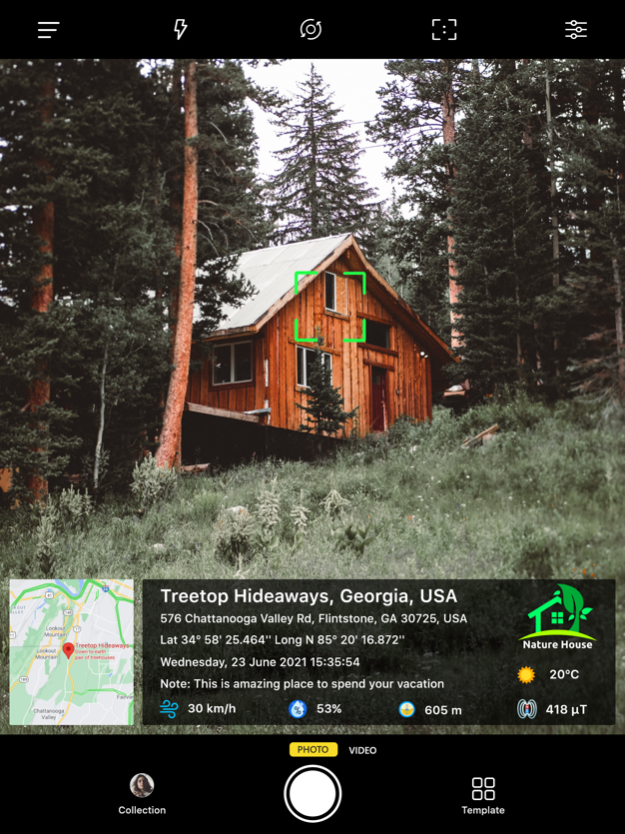
Regardless of whether It's your moment recollections or your visit at a specific destination, with GPS Map camera stamp application, add & stamp Date, time, Map, Latitude, Longitude, Altitude, Weather, Magnetic field, Compass to Your Camera Photos.
Track Live location along with your captured photos by GPS Map Camera: Geotag Photos Application. Send your Geo Location of Street / Place added photos to your Family & Friends, and let them know about your best earth travel memories and movements.
How to add GPS map location on photos?
~ Install GPS Map Camera: Geotag Photos From App Store.
~ Select Advance or classic Templates, Arrange Formats of Stamps, Change Settings according to Your requirement of GPS map Location Stamp
~ Add GPS Location stamps automatically to your clicked pictures
Interesting Features:
~ Get Custom GPS camera with Grid, Ratio, Front & Selfie camera, Flash, Focus, Mirror, Timer, capture sound Support
~ Set Map data as Automatic
~ Classic Template contains automatically fetched stamp details
~ In Advance Template Section:
- Custom maps options: Change Map type from Normal, Satellite, Terrain, Hybrid Options
- Address: Add your selected Automatic location on the Photo
- Lat/Long: Set GPS Coordinates from DMS or Decimal Options for GPS Stamp
- Date & Time: Add Date & Timestamp from various formats as an image tag.
- Logo: Upload your own brand logo
- Note: Write relatable Notes
- Hashtags: You can also add hashtags related to your photos with this GPS app
- Weather: Either in Fahrenheit or Celsius, Measure Temperature Units
- Compass: Auto compass direction
- Magnetic Field: Auto magnetic field Details
- Wind: Measure Wind speed
- Humidity: Auto Humidity measurement
- Pressure: Measure pressure of the place
- Altitude: It will automatically calculate Altitude
- Accuracy: Get auto accuracy on image
Why to have GPS Map Camera Application in Your Smartphone
- To Add Satellite Map Stamp on Photos
- To Add GPS Map Location Stamp to Photos
- To Add Geotag Stamp on photos
- To Add Photo Location stamp
- To Add Date Timestamp
- To Add Longitude, Latitude, Address, Date Time, Location stamp to Photos
- To Check GPS tracker Stamp on Photos
- To Get Geo Location image Stamp
- Camera timestamp, having custom stamps for adding details manually
Most Efficient Application For Following Groups of People:
-Travelers & Explorers can effectively utilize Geo-tagging camera app
- People who associated with business related to real estate, Infrastructure, Architecture can easily apply GPS Map Location stamp to their Site Photos
- Individuals having Destination celebrations of events like Wedding, Birthdays, Festivals, Anniversaries, etc. Can have their current GPS location stamp on the picture.
- Anyone who wants to add GPS Details on their photo as a GPS notecam can use the App.
- Persons having outstation Meetings, conferences, Conclaves, Meetups, Events arranged by companies or Institutions solving and serving a particular purpose
- Travel, Food, Fashion & Art Bloggers can advance their experiences by adding GPS Location through GPS Map Cam
- Place Oriented businesses, where You require sending images with Live Location To Clients
For experimenting with such Interesting Features, MUST Download GPS Map Camera: Geotag Photos Application Right now in your Smartphone.
Do not forget to share your best experiences with us through Rate & Review.
Apr 23, 2024
Version 1.3.7
- Image delete and share option in Gallery
Previous Versions
Here you can find the changelog of GPS Map Camera: Geotag Photos since it was posted on our website on 2021-12-18 05:07:49.
The latest version is 1.3.7 and it was updated on 2024-04-26 15:52:07. See below the changes in each version.
GPS Map Camera: Geotag Photos version 1.3.7
Updated At: 2024-04-23
Changes: Apr 23, 2024
Version 1.3.7
- Image delete and share option in Gallery
GPS Map Camera: Geotag Photos version 1.3.6
Updated At: 2024-04-10
Changes: Apr 10, 2024
Version 1.3.6
- Image delete and share option in Gallery
GPS Map Camera: Geotag Photos version 1.3.4
Updated At: 2024-01-17
Changes: Jan 17, 2024
Version 1.3.4
- Bug fixes & improve performance
GPS Map Camera: Geotag Photos version 1.3.3
Updated At: 2023-12-18
Changes: Dec 18, 2023
Version 1.3.3
- MGRS format added in lat long
GPS Map Camera: Geotag Photos version 1.3.2
Updated At: 2023-11-30
Changes: Nov 30, 2023
Version 1.3.2
- MGRS format added in lat long
GPS Map Camera: Geotag Photos version 1.3.1
Updated At: 2023-10-26
Changes: Oct 26, 2023
Version 1.3.1
- UI enhancement
- Added Camera Level
GPS Map Camera: Geotag Photos version 1.3
Updated At: 2023-10-23
Changes: Oct 23, 2023
Version 1.3
- UI enhancement
- Added Camera Level
GPS Map Camera: Geotag Photos version 1.2.25
Updated At: 2023-09-27
Changes: Sep 27, 2023
Version 1.2.25
- iOS 17 camera captured orientation issue solved
GPS Map Camera: Geotag Photos version 1.2.23
Updated At: 2023-07-25
Changes: Jul 25, 2023
Version 1.2.23
- Stamp template extra small size added
GPS Map Camera: Geotag Photos version 1.2.22
Updated At: 2023-06-05
Changes: Jun 5, 2023
Version 1.2.22
- Added Plus Codes
- Bug fixes & performance improved